Saturday, March 13, 2010

Living in Paradise


Paradise is a place in which existence is positive, harmonious and timeless. It is conceptually a counter-image of the miseries of human civilization, and in paradise there is only peace, prosperity, and happiness. Paradise is a place of contentment, but it is not necessarily a land of luxury and idleness. It is often used in the same context as that of utopia.
Paradisaical notions are cross-cultural, often laden with pastoral imagery, and may be cosmogonical or eschatological or both. In eschatological contexts, paradise is imagined as an abode of the virtuous dead. In Christian and Islamic understanding heaven is a paradisaical relief, evident for example in the Gospel of Luke when Jesus tells a penitent criminal crucified alongside him that they will be together in paradise that day. In Native American beliefs, the other-world is an eternal hunting ground. In old Egyptian beliefs, the other-world is Aaru, the reed-fields of ideal hunting and fishing grounds where the dead lived after judgment. For the Celts, it was the Fortunate Isle of Mag Mell. For the classical Greeks, the Elysian fields was a paradisaical land of plenty where the heroic and righteous dead hoped to spend eternity.

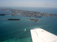
Now that you know the meaning of Paradise, I will share with you what it looks like! Key West is my home and is Paradise to me!

Thursday, September 24, 2009

Fort Jefferson


Fort Jefferson is an unincorporated community and ghost town in Monroe County, Florida, United States. It is located on Garden Key in the lower Florida Keys within the Dry Tortugas National Park, about 70 miles (110 km) west of the island of Key West.
Fort Jefferson is a massive but unfinished coastal
fortress. It is the largest masonry structure in the Western Hemisphere, and is composed of over 16 million bricks.
In late December 1824 and early January 1825, about five years after Spain sold Florida to the United States for $5 million, U.S. Navy Commodore David Porter inspected the Dry Tortugas islands. He was on the lookout for a site for a naval station that would help suppress piracy in the Caribbean. Unimpressed with what he saw, he notified the Secretary of the Navy that the Dry Tortugas were unfit for any kind of naval establishment. He reported that they consist of small sand islands a little above the surface of the ocean, have no fresh water, scarcely enough land to place a fortification, and in any case are probably not solid enough to bear one.
While Commodore Porter thought the Dry Tortugas were unfit for a naval station, others in the U.S. government thought the islands were a good location for a
lighthouse to guide ships around the area's reefs and small islands. A small island called Bush Key, later called Garden Key, was selected as the site for the lighthouse, which became known as Garden Key Light. Construction began in 1825 and was completed in 1826. The 65-foot lighthouse was constructed of brick with a whitewashed exterior. A small white cottage for the lighthouse keeper was constructed beside the lighthouse.
In May 1829, Commodore
John Rodgers stopped at the Dry Tortugas to evaluate the anchorage. Contrary to Commodore Porter's experience, Rogers was delighted with what he found. The Dry Tortugas, he reported, consisted of 11 small keys and surrounding reefs and banks, over which the sea broke. There was an outer and an inner harbor. The former afforded a safe anchorage at all seasons, and was large enough to let a large number of ships ride at anchor. Of more importance, the inner harbor combined a sufficient depth of water for ships-of-the-line, with a narrow entrance of not more than 120 yards. Rogers said that if a hostile power should occupy the Dry Tortugas, United States shipping in the Gulf would be in deadly peril, and "nothing but absolute naval superiority" could prevail. However, if occupied and fortified by the U.S., the Dry Tortugas would constitute the "advance post" for a defense of the Gulf Coast. A series of engineering studies and bureaucratic delays consumed the next 17 years, but the construction of Fort Jefferson (named after the third President, Thomas Jefferson) was finally begun on Garden Key in 1846. The new fort would be built so that the existing Garden Key lighthouse and the lighthouse keeper's cottage would be contained within the walls of the fort. The lighthouse would continue to serve a vital function in guiding ships through the waters of the Dry Tortugas Islands until the current metal light tower was installed atop an adjacent wall of the fort in 1876. The original brick lighthouse tower was taken down in 1877.
The design called for a three-tiered six-sided 420 heavy-gun fort, with two sides measuring 325 feet, and four sides measuring 477 feet. The walls met at corner bastions, which are large projections designed to allow defensive fire along the faces of the walls they joined. The heavy guns were mounted inside the walls in a string of open casemates, or gunrooms, facing outward toward the sea through large openings called embrasures. Fort Jefferson was designed to be a massive gun platform, impervious to assault, and able to destroy any enemy ships foolhardy enough to come within range of its powerful guns. Living quarters for soldiers and officers, gunpowder magazines, storehouses, and other buildings required to maintain the fort were located on the parade ground inside the fort's massive brick walls. The Army employed civilian machinists, carpenters, blacksmiths, masons, general laborers, the resident prisoner population, and slaves to help construct the fort. By 1863, during the Civil War, the number of military convicts at Fort Jefferson had increased so significantly that slaves were no longer needed. At the time, there were 22 black slaves employed on the project. Fort Jefferson's peak military population was 1,729. In addition, a number of officers brought their families, and a limited number of enlisted personnel brought wives who served as laundresses (typically four per company). There were also lighthouse keepers and their families, cooks, a civilian doctor and his family, and others. In all, there were close to 2,000 people at Fort Jefferson during its peak years. In order to support such a large population in an area lacking fresh water, an innovative system of cisterns was built into the walls of the fort. Sand-filled columns were placed at regular intervals in the inner walls, spanning their height from the roof to the foundation. The columns were intended to filter rainwater from the rooftop for long-term storage in a series of underground chambers. However, the system was never used in practice, as the enormous weight of the outer walls caused them to subside; this created cracks in the cisterns, allowing seawater to contaminate the fresh water supply.
Park Designation
On January 4, 1935, President
Franklin D. Roosevelt, who visited the area by ship, designated the area as Fort Jefferson National Monument. It was listed on the National Register of Historic Places on November 10, 1970. On October 26, 1992 the Dry Tortugas, including Fort Jefferson, was established as a National Park. The islands still do not exhibit any standing fresh water or even seasonal streams, hence the "dry" name. Owing to the potential difficulties of survival in such conditions, one of these islands was used as the location for filming a military survival film used to train aircraft personnel

Wednesday, July 1, 2009

Southern Most City


Southernmost City

Monument marking the southernmost point in the continental United States accessible by civilians, is located at the corner of South Street and Whitehead Street. One of the biggest attractions on the island is a concrete replica of a buoy at the corner of South and Whitehead Streets that claims to be the southernmost point in the contiguous 48 states The point was originally just marked with a sign, which was often stolen. In response to this, the city of Key West erected the now famous monument in 1983. Brightly painted and labeled "SOUTHERNMOST POINT CONTINENTAL U.S.A.", it is one of the most visited and photographed attractions in Key West. However, the marker is not located at the southernmost point in the United States, as discussed below:
Land on the
Truman Annex property just west of the buoy is the true southernmost point, but it has no marker since it is U.S. Navy land and cannot be entered by civilian tourists. The private yards directly to the east of the buoy and the beach areas of Truman Annex and Fort Zachary Taylor Historic State Park also lie farther south than the buoy. The farthest-south location that the public can visit is the beach at the state park for a small entrance fee. The farthest-south location that the public can visit for free is the seaward end of the White Street Pier. Florida's southernmost point is Ballast Key, a private island owned by David Wolkowski, a wealthy developer, about ten miles west of Key West. Although Ballast Key is located within both the Key West National Wildlife Refuge and the Florida Keys National Marine Sanctuary, signs on the island strictly prohibit unauthorized visitors.
The claim "90 Miles to Cuba" on the monument isn't entirely accurate either, since Cuba at its closest point is 94 statute miles from Key West.

Tuesday, May 12, 2009

The Sinking of the Vandenberg


THE GEN. HOYT S. VANDENBERG AT A GLANCE :

The ship is 520 feet long, 13,300 tons,100 feet tall at its highest peak.

The keel will lie on sand and hardbottom at 140 feet. The 10 by 30 feet crow's nest platform and the dish antennas will be only 40 feet from the surface. Most of the deck structures will be at 50 to 90 feet. Seven by 10 foot holes will offer access to the top four decks. Eighteen stair towers, elevator shafts and cargo hold shafts will offer vertical access.

A new marine life habitat this ship will be the most spectacular artificial reef ever prepared especially for diving. There will be plenty of very divable structure at depths of 40 to 140 feet. Shallow structures include the 30 by 10 foot crows nest, perfect for beginning dive classes, the great 40 foot dish antennas, and the tops of the bridge and communications center.
The 25 foot tall rudder and prop will be a fantastic deep dive at 140 feet. The four open decks at approximately 70-100 feet will be penetrated horizontally with 8 by 10 foot openings on each side, and vertical elevator shafts, cargo holds and stair towers. The vast structure will teem with marine life, inside and out.

Following an 1,100-mile voyage and more than a decade of planning and acquring funding resources, the Florida Keys newest artificial reef, the ex-military missile tracking ship Gen. Hoyt S. Vandenberg arrived in Key West Wednesday.
The Vandenberg is docked behind the USS Mohawk, at the East Quay Wall in Truman Annex Harbor.
Final preparations to sink the ship is beginning. Project organizers said the scuttling should take place sometime between May 20 and June 1, about six miles south of Key West in 140 feet of water in the Florida Keys National Marine Sanctuary.
That work primarily involves the cutting of hundreds of large holes on the ship’s decks and sides to help ensure the vessel sinks in an upright position.
Public tours of the Vandenberg will not be allowed due to safety concerns, but people can see the ship at Truman Waterfront while it is docked at the East Quay wall.
A security fence will prohibit onlookers from getting too close to the ship, but there will be plenty of viewing access, said Key West city spokeswoman Alyson Crean.
Sometime before June 1, the same procession of tugboats will lead the Vandenberg back out of Key West's main ship channel and to a location about six miles offshore.
Once in position, and held there with more than 30 tons of steel anchors, the Vandenberg will make its final voyage -- 140 feet to the bottom of the ocean.

Tuesday, April 7, 2009

A Day in Paradise


Key West is a city in Monroe County, Florida, United States.

The city encompasses
Key West the namesake island, the part of Stock Island north of U.S. 1 (the Overseas Highway) (east), Sigsbee Park (north, originally known as Dredgers Key), Fleming Key (north), and Sunset Key (west, originally known as Tank Island). Nearby Key Haven (northeast), the part of Stock Island south of U.S. 1 (east), and Wisteria Island, better known as Christmas Tree Island (northwest), are in unincorporated Monroe County. Both Fleming Key and Sigsbee Park are part of the NAS Key West and are inaccessible by civilians.
Key West is the
county seat of Monroe County.
Key West is known as the southernmost city in the
Continental United States. It is also the southern terminus of U.S. 1, State Road A1A, and the East Coast Greenway.

Key West is 129 miles (207 km) southwest (229.9
degrees) of Miami, Florida, (about 160 driving miles) and 106 miles (170 km) north-northeast (21.2 degrees) of Havana, Cuba. Cuba, at its closest point, is 94 statute (81 nautical) miles south.
Key West is a
seaport destination for many passenger cruise ships. The Key West International Airport provides airline service. Hotels and guest houses are available for lodging.
Naval Air Station Key West is an important year round training site for naval aviation due to the superb weather conditions. It is also a reason the city was chosen as the Winter White House of President Harry S. Truman.
The
central business district primarily comprises Duval Street, and includes much of the northwest corner of the island along Whitehead, Simonton, Front, Greene, Caroline, and Eaton Streets and Truman Avenue.

The official city motto is "One Human Family."

Cayo Hueso (pronounced [ˈkaʎoˈweso]) is the original Spanish name for the island of Key West. Spanish-speaking people today also use the term Cayo Hueso when referring to Key West. It literally means "bone key". It is said that the island was littered with the remains (bones) from an Indian battlefield or burial ground. The most widely accepted theory of how the name changed to Key West is that it is a false-friend anglicization of the word, on the ground that the word "hueso" (pronounced [ˈweso]) sounds as if it could mean "west" in English. Other theories of how the island was named are that the name indicated that it was the westernmost Key, or that the island was the westernmost Key with a reliable supply of water. Many businesses on the island use the name, such as Casa Cayo Hueso, Cayo Hueso Resorts, Cayo Hueso Consultants, Cayo Hueso y Habana Historeum, etc. In 1763, when Great Britain took control of Florida, the community of Spaniards and Native Americans were moved to Havana. Florida returned to Spanish control 20 years later, but there was no official resettlement of the island. Informally the island was used by fishermen from Cuba and from the British Bahamas, who were later joined by others from the United States after the latter nation's independence. While claimed by Spain, no nation exercised de facto control over the community there for some time.

Conchs
Many of the residents of Key West were
immigrants from the Bahamas, known as Conchs (pronounced 'conks'), who arrived in increasing numbers after 1830. Many were sons and daughters of Loyalists who fled to the nearest Crown soil during the American Revolution. In the 20th century many residents of Key West started referring to themselves as "Conchs", and the term is now generally applied to all residents of Key West. Some residents use the term "Conch" to refer to a person born in Key West, while the term "Freshwater Conch" refers to a resident not born in Key West but who has lived in Key West for seven years or more. However, the true original meaning of Conch applies only to someone with European ancestry who immigrated from the Bahamas. It is said that when a baby was born, the family would put a conch shell on a pole in front of their home.
Many of the Bahamian immigrants live in an area of Old Town next to the
Truman Annex called "Bahama Village."
Major
industries in Key West in the early 19th century included fishing, salt production, and salvage. In 1860 wrecking made Key West the largest and richest city in Florida and the wealthiest town per capita in the U.S. A number of the inhabitants worked salvaging shipwrecks from nearby Florida reefs, and the town was noted for the unusually high concentration of fine furniture and chandeliers that the locals used in their own homes after salvaging them from wrecks.


Saturday, March 21, 2009

Key West Sights

Looking toward the Atlantic Ocean

Atlantic Side

Higgs Beach

Cruise Ship leaving

Salt Pond Tarpons
Smathers Beach
Key West from the Gulf
Rebecca Shoals Lighthouse early 1900's

Saturday, March 14, 2009

Around Town

Atlantic Side
Key West Lighthouse

Stock Island Shrimpboats

Smathers Beach

Sunset Key

Fort Jefferson

Conch Shells

Sunset View from Within the Island

Looking For Supper